OutDoors France - GPS with IGN Topo Maps and Walks 2
Device: iOS Universal
Category: Navigation
Price: Free, Version: 1.1 -> 2 (iTunes)
 Description:
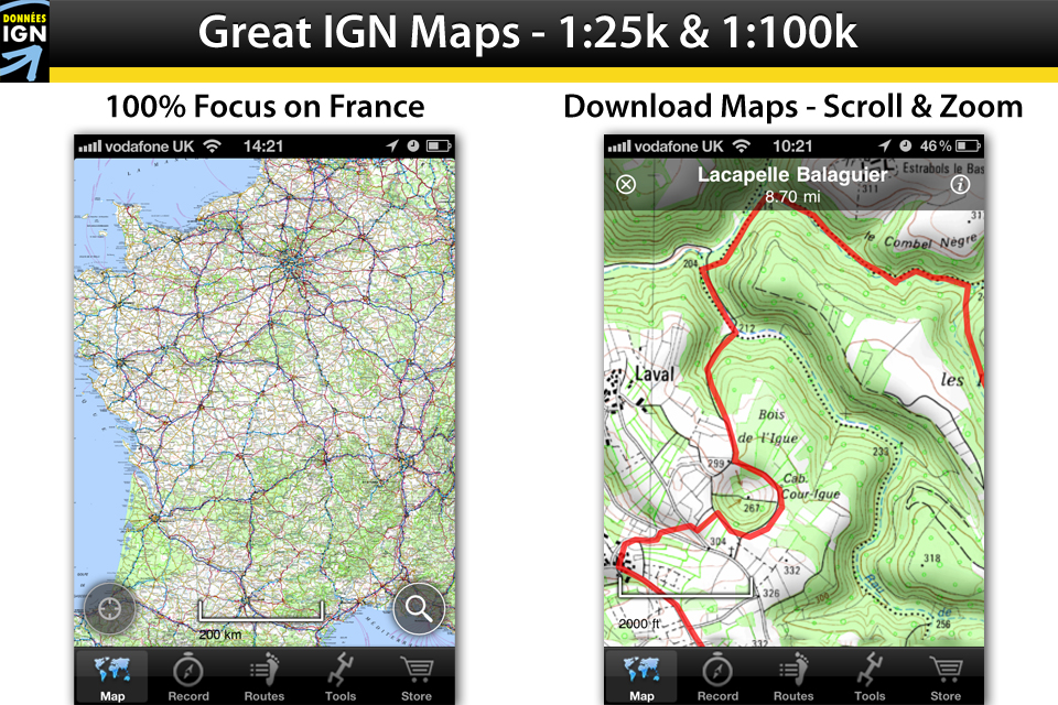
OutDoors France is the complete IGN mapping and GPS app for France’s walkers, runners, cyclists and mountaineers. A simple and intuitive interface delivers the full detail of France’s superb topographic maps from IGN (L’Institut Géographique National)- France’s official maps for the countryside and all outdoor hobbies (similar to Ordnance Survey in UK or BKG in Germany). All the most detailed maps for the whole of France are useable the moment you download the app. These include the official IGN 1:25k maps for hiking and 1:100k maps for cycling. As well as viewing online, you can permanently download any area of France so you can use the maps, and your iPhone, anywhere, regardless of phone signal. • DETAILED TOPOGRAPHIC MAPS FOR THE WHOLE OF FRANCE. • FULLY FUNCTIONAL GPS FUNCTIONS. • CREATE, RECORD, EDIT, FOLLOW AND SHARE ROUTES.- “Extremely easy to use and looks great.” -[Trek & Mountain Magazine] - “Excellent app, very useful for keen hikers.” -[Apps Magazine] - “Many useful features...excellent value”- [OutDoor Enthusiast Magazine]ALL OFFICIAL IGN MAPS OF FRANCE AVAILABLE IMMEDIATELY• View the whole of France at all levels of detail immediately.• Going for a Hike? Purchase and permanently download any area you wish via the in-app store. • Finds your location in seconds and shows direction of view.• Seamlessly scroll and zoom between maps and areas. • No need for phone signal.• Current Position will stay centre to enable hands-free use (great for cycling). • Super fast search of 100,000 French place names.• Supports multi-tasking to reduce battery consumption (in our hill-walking tests, the battery can last 10+ hours. Just remember to turn off 3G & Wifi; this is done in iPhone Settings.)FULLY FUNCTIONAL GPS• Record your Route with statistics; watch as it records your route on the map. • View current speed, average speed, distance, altitude, time elapsed and more. • In-built Compass. • View current Longitude/Latitude and Grid Reference. IMPORT AND EXPORT ROUTES – SEAMLESSLY MOVE ROUTES BETWEEN DEVICES• Create a free www.outdoorsgps.com Route Builder Account- quickly and easily.• Build and Edit routes on iPhone or Website.• Then seamlessly move routes between iPhone, iPad and OutDoors Website in seconds. • Save/Backup your Routes to the OutDoors website to view, edit and share later.• Find and Import your personal Routes from the online route builder to your iPhone/iPad.• Search and download routes from the OutDoors database to your iPhone/iPad.• Import, Export and edit GPX files.YOUR CHOICE: ONLINE OR DOWNLOADED• For Planning at Home: After the first 30 days, you can subscribe to view all French maps online for an additional 12 months for just £4.99- ideal for planning at home or office, near a 3G or Wifi signal.• For Hiking and Biking in the Country: Alternatively, you can choose to purchase and download a specific area to store permanently on the device - for use where there is no phone signal. • Downloaded Maps come with a lifetime license.• Delete and reinstall map areas anytime.• Share your maps between iPhone and iPad devices at no extra cost.TOP TIPS: For Top Tips on using your iPhone with OutDoors out in the wild, go to our web-site here; http://outdoorsgps.com/tips.php.NOTE: Continued use of GPS running in the background can dramatically decrease battery life.
What's New
update
OutDoors France - GPS with IGN Topo Maps and Walks